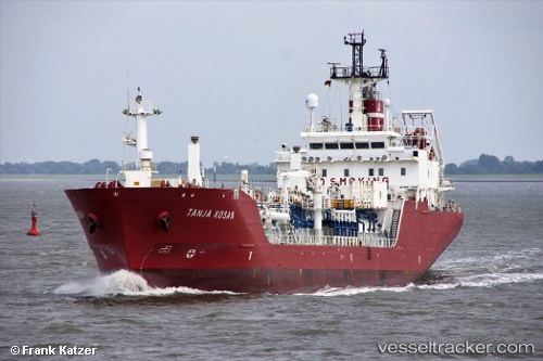
vessel TANJA KOSAN IMO: 9174361, LPG Tanker vesseltracker.com
Vessel TANJA KOSAN IMO: 9174361, LPG Tanker
MMSI: 256036000 callsign: 9HA5666 size: 107x107

Find the position of the vessel TANJA KOSAN on the map. The latter are known coordinates and path.

marine traffic ship tracker show on live map

The current position of vessel TANJA KOSAN is 37.86269 lat / 23.74277 lng. Updated: 2024-11-01 10:13:47 UTC

Currently sailing under the flag of Malta

TANJA KOSAN built in 1999 year

Deadweight:
5996 t

Details:


Last coordinates of the vessel:
2024-11-01 10:13:47 UTC, 37.86269, 23.74277, course: 72, speed: 0

Track of the vessel in the last 14 days


Most frequent ports a vessels calls at TANJA KOSAN (256036000):

Eleusis, traffic: 6
Skaramangas, traffic: 6
Port Said, traffic: 4
Ulsan, traffic: 3
Singapore, traffic: 2
Thessaloniki, traffic: 2
Ras Gharib, traffic: 2
Ra’S Shukhayr, traffic: 2
Bur Ibrahim, traffic: 2
Sambu, traffic: 2
Cape St. Jacques, traffic: 1
Shimonoseki, traffic: 1
Gladstone Harbor, traffic: 1
Imabari, traffic: 1
Jubail, traffic: 1

Link to the map:


Find another ship

TANJA_KOSAN (256036000) last ports (portcalls and passsages)

Salamis | 2024-07-22 04:22:12
Eleusis | 2024-07-19 06:00:17
Eleusis | 2024-07-15 04:59:21
Eleusis | 2024-07-01 10:03:38
Eleusis | 2024-06-18 08:00:24
Eleusis | 2024-06-14 07:25:58
Eleusis | 2024-06-05 12:06:33
Singapore | 2024-02-20 10:28:42
Sambu | 2024-02-20 10:05:17
Singapore | 2024-02-05 08:31:09
Torres Strait | 2023-11-16 20:08:25
Gladstone Harbor | 2023-11-11 13:04:52
Ulsan | 2023-10-13 13:54:45
Ulsan | 2023-09-28 04:27:05
Wakamatsu | 2023-07-10 07:23:29
Ube | 2023-07-10 05:30:20
Imabari | 2023-07-08 18:22:16
Gemalink | 2023-05-07 00:37:02
Vung Tau | 2023-05-06 23:37:53
Ulsan | 2023-02-05 06:00:55
Jubail | 2022-02-06 21:37:45
Ras Gharib | 2022-01-25 22:47:34
Port Said | 2022-01-25 05:10:27
Thessaloniki | 2022-01-06 02:50:01
Port Said | 2022-01-03 15:00:01
Bur Ibrahim | 2022-01-03 05:05:00
Ra’S Shukhayr | 2022-01-01 23:26:04